DESIGN AND CONSTRUCTION

Build Facilities | Protect Life and Property

MISSION STATEMENT OF THE VENTURA COUNTY PUBLIC WORKS AGENCY – WATERSHED PROTECTION (VCPWA-WP) DESIGN AND CONSTRUCTION (D&C) SECTION: ‘BUILD FACILITIES TO PROTECT LIFE, PROPERTY AND WATERSHEDS FROM THE DANGERS OF FLOODS’. 

The D&C design teams strive to engineer quality designs and construct facilities that protect the communities and watershed environments of Ventura County through a combination of in-house design engineering, project oversight and management, and employment of highly qualified consultants. Public Works Inspectors use their construction experience to work with contractors and residents to complete projects safely while following construction standards. Our Environmental Services section provides environmental compliance guidance and services to District, Division, and County citizens as required by federal, state, and local regulations and policies. 

The Environmental Services section provides environmental compliance guidance and services to District, Division, and County citizens as required by federal, state, and local regulations and policies.
Duties Include:

  • Compliance with regulatory requirements for capital improvements from project concept through implementation. Regulations include the California Environmental Quality Act, National Environmental Policy Act, Clean Water Act, California Department of Fish and Game Code, federal and state endangered species acts, and many others.
  • Develop and implement cost effective mitigation for District projects.
  • Balance flood control and environmental stewardship through planning at the watershed level.
  • Ensure consistency with the County General Plan policies.
  • Share information with the public and regulators.
  • Provide technical assistance regarding environmental issues at all stages of capital and private projects.
  • Work to streamline permitting and regulatory procedures.
  • Develop applications and administer grants for District projects.

Contacts

Pam Lindsey Watershed Ecologist, Section Supervisor (805) 654-2036 Pam.Lindsey@ventura.org
Angela Bonfiglio Allen Environmental Planner (805) 477-7175 Angela.Bonfiglio@ventura.org
Donna Hebert Environmental Planner (805) 477-1976 Donna.Hebert@ventura.org


Related Links

Permitting

Biological Information

Invasive Species

Additional Agency Resources

Current Improvement Construction Projects

VCPWA-WP is constructing a new grade control structure in the Arroyo Simi approximately 100 feet downstream of the Leta Yancy Pedestrian Bridge in the City of Moorpark. Grade control structures help control the flow of water in the Arroyo Simi. The existing facility was damaged during the storm seasons of 1998 and 2005, and completely failed late in 2014. The new grade control structure will prevent the channel bed and banks from future erosion and protect the existing pedestrian bridge, storm drain laterals, adjacent properties, and upstream facilities.  

The project components include removal of the existing failed concrete and rock grade control stabilizer with a new concreted rock riprap grade control structure, concreted rock riprap bank protection, steel sheet pile end sill with reinforced concrete pile cap, and a rock riprap stilling basin. Construction incorporates a concrete overpour and V-ditch to direct offsite flows, access roads, fencing, and gates.   

The Matilija Creek Giant Reed Re-Treatment Project was initiated in Fall 2007 with the goal of eradicating a suite of non-native plant species that heavily infested the floodplain of the main stem of the Ventura River and Matilija Creek. The purpose of the project is to improve habitat quality in the floodplains of these drainages in advance of the future removal of Matilija Dam. Re-treatment of the project area for the same species targeted during the initial treatment began in May 2008 and have continued from one up to three times annually to date. Although complete eradication of the target species throughout the project area is not possible because of constant input of propagules from source populations beyond the boundaries of the project area, the cumulative effect of these re-treatments have transformed floodplain habitats that formerly were infested with invasive, non-native vegetation into native-dominated plant communities where the target species are a minor component.

DESIGN PHASE PROJECTS

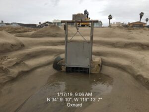
The project involves demolishing and removing the existing reinforced concrete (RC) outfall structure, removing approximately 46 linear feet of asbestos cement pipe (ACP), constructing a new RC outfall structure 30 feet upstream from its current location, installing a 30-inch diameter RC pipe and RC collar to connect existing ACP to the new RC outfall structure with ten (four 18-inch, two 16-inch, and four 14-inch-diameter) treated timber piles supporting the weight of the above-mentioned structure and installation of a 42×42-inch stainless steel sliding gate, and appurtenances.

A storm drain system was installed in the Silver Strand community beginning in 1976. The age of the system, combined with a corrosive coastal environment has led to the systems needing updating. The Silver Strand community is located on very flat terrain and is susceptible to periodic localized flooding. The outfall of the pump station terminates at the beach near the tidal zone requiring frequent maintenance during winter months to remove sand from blocking the outlet pipe.


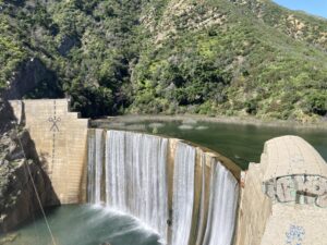
The Matilija Dam, originally constructed in 1947, has outlived its usefulness. Since construction it has filled with approximately 8 million cubic yards of sediment, and the condition of the dam itself has deteriorated so it no longer serves the purpose of providing water supply and flood protection to the community.

The Matilija Dam Ecosystem Restoration Project has many elements leading up to eventual dam removal, providing many benefits. See webpage for more information: https://www.vcpublicworks.org/wp/mderp/


The SCR-1 levee, constructed in 1961 by the U.S. Army Corps of Engineers (USACE) and owned and maintained by the Watershed Protection District (WP), extends from Highway 101 to South Mountain along the east bank of the Santa Clara River. It protects from flooding parts of the City of Oxnard, the Riverpark development, and unincorporated areas, including the community of El Rio. It has been determined that the levee no longer meets FEMA standards and is in need of rehabilitation.

Link to webpage:  https://www.vcpublicworks.org/wp/santa-clara-river/santaclarariverlevee

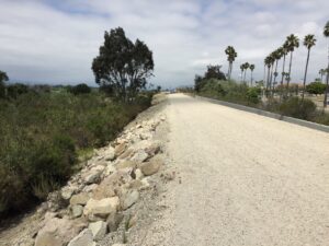
Rehabilitation is needed to comply with FEMA levee certification requirements. Phase I (2018) – downstream of UPRR. Raised levee, added rock riprap bank protection, construction of floodway, drainage system, fencing and appurtenances.  

Phase II – SCR-3 Levee Rehab Completion & Habitat Enhancement Project – Coordinated effort of County, City of Oxnard, private development and CA DWR funding. Design and construction of a new levee, flood walls and flood gate downstream of Union Pacific Railroad crossing to meet the Federally mandated levee certification regulations. 

RECENTLY COMPLETED IMPROVEMENT PROJECTS

Removal of 780 linear feet of trapezoidal concrete channel along J Street and 90 linear feet of reinforced concrete box culvert under Hueneme Road, construction of 800 linear feet of reinforced concrete box conduit and 70 linear feet of reinforced concrete open channel transition structures, traffic detour, street paving, traffic signal relocation, curb, gutter and sidewalk reconstruction, a waterline relocation, and appurtenant work. (J Street Drain was renamed to tšumaš Creek by the VC Board of Supervisors on August 4, 2015).

The improvements address community concerns about trash in the creek and the desire for a future linear park should grant funding become available to do so in the future. This is part of a series of projects along tšumaš Creek.

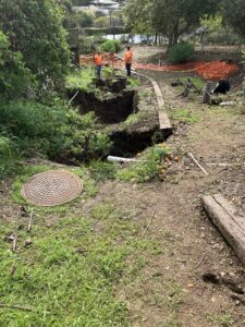
An emergency contract was awarded to take immediate action to mitigate the fast expansion of sinkholes threatening seven residential properties off Foothill Road in the City of Ventura. The uncontrolled expansion of the sinkholes was a result of the recent storm events of late December 2022 and the early weeks of January 2023. The existing 55-year-old metal pipe failed, causing stormwater to undermine the pipe and eroded the soil underneath it. The failed corrugated metal pipe (CMP) was buried in the backyard of seven residential properties. The most clear and imminent threat was a sinkhole that had exposed the reinforced concrete footing of a complex and cascading retaining wall system that supports a swimming pool and a patio area. In addition, storm flows caused significant erosion around and underneath the pipe as they have been naturally redirected underneath the corroded sections of the pipe, thus discharging a large volume of sediment into Arundell Barranca. The contractor mobilized to take immediate action to protect the project site, stabilize the retaining wall and extensive sinkhole, and reestablish the failing CMP storm drain system to a functional state to prevent further dirt/sediment discharge into its receiving channel (Arundell Barranca).


For more information please read: Sinkholes in Ventura backyards require emergency fixes

The finished project will increase public safety by improving access along the Ferro Ditch to the Ferro Debris Basin for maintenance and emergency response during flood events. Additional benefits include increased protection of adjacent agricultural lands, reduced erosion, and channel maintenance costs, and improved water quality in receiving waters including the Mugu Lagoon.


The project consists of the replacement of approximately 1,687 linear feet of earthen and intermittent concreted rock lined sections of trapezoidal channel with 10 linear feet of concrete box culvert, 35 linear feet of RC open rectangular channel, 30 linear feet of concrete transition between the rectangular channel and trapezoidal channel sections,1,507 feet of rock lined trapezoidal channel, 40 linear feet of reinforced concrete flood control wall with floodgates, traffic control, agricultural drainage line relocation, removal and reinstallation of rock in a stilling basin, contour grading and appurtenant work.

This construction project provided repairs and enhancements to the downstream end of the Newbury Park Drain No. 1 from its confluence with the South Branch Arroyo Conejo in Newbury Park to Michael Drive. The channel is located just east of Wendy Drive. Over the years, the corrugated metal pipe (CMP) had deteriorated and the unprotected trapezoidal earth channel experienced significant surface erosion. Without the repairs, the adverse processes will exacerbate the poor condition of the CMP and the trapezoidal channel.

This project consisted of the replacement of existing 8’ diameter corrugated metal pipe culvert with a 12’ wide by 8’ high reinforced concrete box culvert, including reinforced concrete outlet and transition structures, and rock lining of a 62’ long by 38’ wide trapezoidal earth channel.

Drainage Improvements – A 2004 study concluded the dam did not meet current standards and modification or removal was recommended. A 2007 study recommended that removal of the dam could be possible without detrimental downstream effects. The debris basin provided little or no flood protection in 10-, 50- or 100-year events. A dam breach would likely overtop Santa Rosa Road by up to seven feet of water. Built in 1957, the original purpose was as a debris basin.

Removal of existing earthen dam and emergency spillway; demolition and removal of 36-inch reinforced concrete (RC) pipe of primary intake structure, 10-inch corrugated metal (CM) bleeder pipe, 24-inch RC and CM outlet pipes, 20 linear feet (LF) of RC transition structure, and a portion of the concreted rock riprap downdrain; vegetation removal and weed control; construction of 45 LF of 14 feet wide by 6 feet high RC box, 20 LF of RC transition structure, removable bollard fence footing, and concreted rock riprap downdrain structure; resurfacing of existing CMB access road and ramp; installation of erosion control blanket and chain-link fence and gates, and appurtenant work.

Removal was followed by restoration of the environment by planting of native plants, and other improvements.

The purpose of the project was to mitigate repeated inundation of the community of Casitas Springs and State Route (SR) 33 from floodwaters, sediment, and debris originating from the Fresno Canyon Watershed and the related undersized storm drain facilities.

The project encompassed the area between where the Fresno Canyon channel outlets the canyon mouth on the east side of State Route 33 to the Ventura River.

The project components included the installation of a 108-inch reinforced concrete (RC) pipe from Fresno Canyon to the Ventura River utilizing both a jacking method (trenchless) and open trench installation, construction of RC floodwalls, RC masonry retaining walls, RC channel and chute, RC box, RC headwalls, rock riprap, concrete v-ditches, access roads of various materials, and asphalt bike path. The project also included the installation of 60-, 48-, and 18-inch RC pipes, and a 21-inch sewer line, manholes, chain link and wood fencing, chain link and pipe gates, and related appurtenances.

The Casitas Springs Fresno Canyon Diversion Project on Vimeo