Santa Clara River Levee Improvements Upstream of Highway 101 (SCR-1) Project
 Project Description: The Santa Clara River Levee (FEMA ID No. 18) Improvements Upstream of Highway 101 (SCR-1) Project consists of structural improvements intended to provide flood protection for residential, public, commercial, industrial, and agricultural areas along the river within the floodplain of the Santa Clara River. The SCR-1 Project also accommodates a future bikeway and incorporates public recreation and education features. The SCR-1 levee system will ultimately protect approximately 1,939 structures in the City of Oxnard in Ventura County. The proposed levee improvements extend from Highway 101 along the existing SCR-1 levee system parallel to the Santa Clara River until Central Avenue Drain, where it deviates from the existing SCR-1 levee and proceeds southeast between the Central Avenue Drain on the south and United Water Conservation District’s (UWCD) Spreading Grounds (Ferro Basin) on the north. Upon passing Ferro Basin, the alignment heads northeast along the eastern edge of Ferro Basin and enters the existing Harry’s Berries agricultural fields before reaching high ground just short of East Vineyard Avenue. The Project occurs along approximately 2 miles of the existing levee system and creates approximately 0.8 miles of new levee segment beginning at the Central Avenue Drain and ending near East Vineyard Avenue.
***Click here to view the SCR-1 Project CEQA page***
Proyecto de Mejoras del Dique del Río Santa Clara Aguas Arriba de la Autopista 101 (SCR-1)
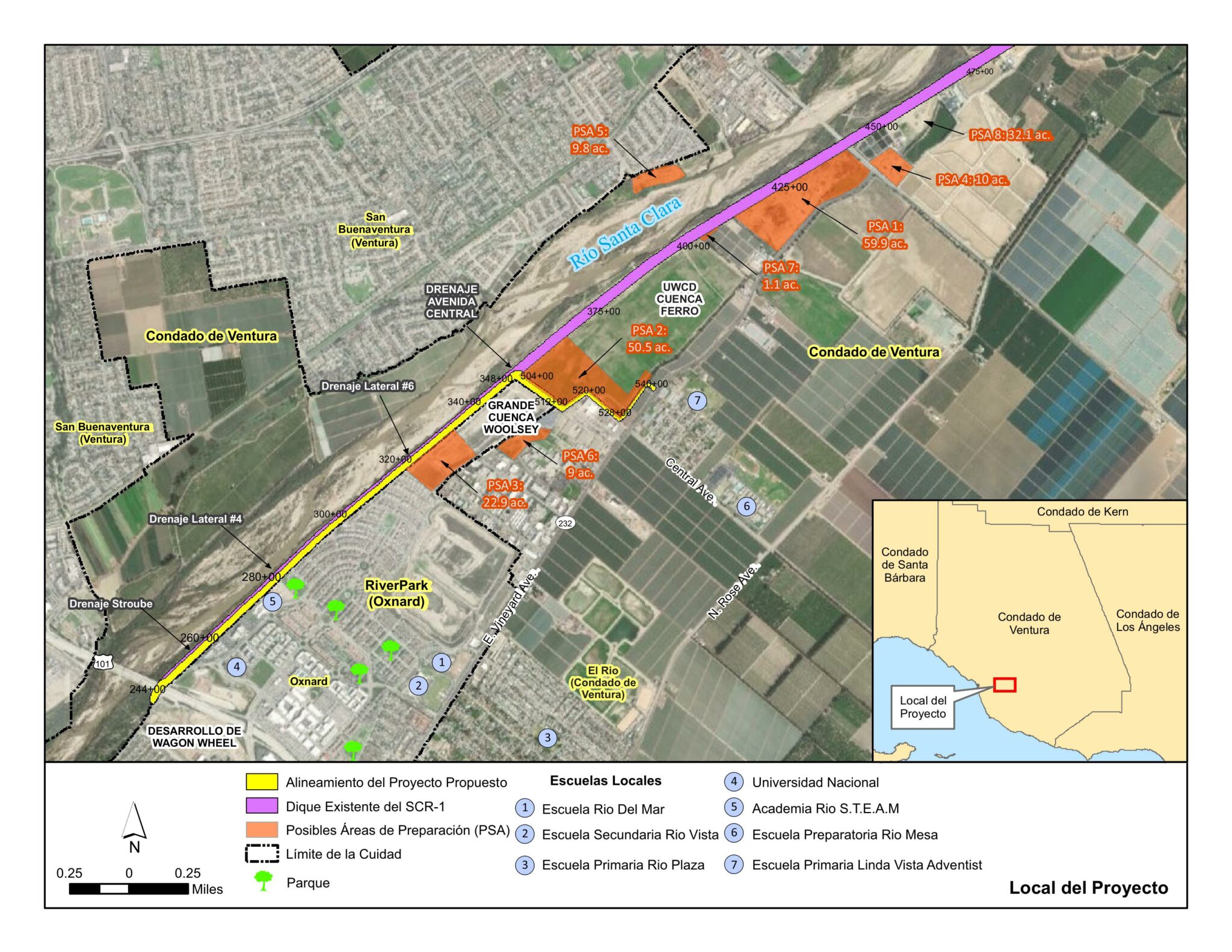 Descripción del Proyecto:: El Proyecto de Mejoras del dique del Río Santa Clara (FEMA ID No. 18) Aguas Arriba de la Autopista 101 (SCR-1) consiste en mejoras estructurales destinadas para brindar protección contra el riesgo de inundaciones para áreas residenciales, públicas, comerciales, industriales, y ágricolas a lo largo del río dentro de la zona de inundación del Río Santa Clara. El Proyecto SCR-1 también acomoda una futura ciclova e incorpora características públicas recreativas y educativas. El sistema de diques SCR-1 protegería aproximadamente 1,939 estructuras en la ciudad de Oxnard en el condado de Ventura. Las mejoras propuestas al dique se extenderían desde la Autopista 101 a lo largo del sistema de diques SCR-1 existente hasta el Drenaje de la Avenida Central, donde se desvía del dique SCR-1 existente y continua hacia el sureste entre el Drenaje de la Avenida Central en el sur y los Terrenos de Extensión (Ferro Basin) de United Water Conservation District (UWCD) en el norte. Al pasar el Ferro Basin, la alineación continua hacia el noreste a lo largo del lado oriental del Ferro Basin y entra en los campos agrícolas existentes de Harry’s Berries antes de llegar a terrenos elevados cerca de East Vineyard Avenue.
***Haga clic aquí para ver la página de CEQA para el Proyecto SCR-1***
